Maps made by the West from the 16th to early 19th century usually resort to using tiles such as: Sea of Chosun, Sea of Korea, Eastern Sea but not Sea of China or Sea of Japan.
During that period, it was found that “Sea of Korea” was most frequently used name even though many other names existed.
The region of the East Sea appeared on the world map as early as 16th century when westerners first started to explore far East, drawing up maps of the region.
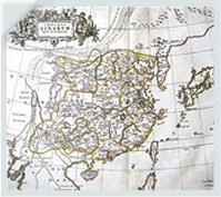
Map of China / Martint / 1655:
Martini(Italian priest of Society of Jesuits) Book of China Map Specified Korea as Corea Peninsula
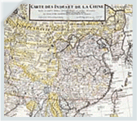
Map of Asia / Drill / 1705:
Specified East Sea as the Eastward Gulf (MER ORIENTALE)
or Sea of Korea (MER DE COREE)
COPYRIGHT (C) 2012 BY OSO CO.LTD.ALL RIGHS RESERVED.
TEL : 02-744-0541│FAX : 02-744-0601│E-MAIL : oso@oso.co.kr
TEL : 02-744-0541│FAX : 02-744-0601│E-MAIL : oso@oso.co.kr
Family Site